
I had planned this walk a few years ago but was never satisfied that I was fit enough. Weall after the last two weeks walks I decided to go for it. I reviewed my walk plan and looked over the map in detail including the satellite view and a 3D fly through offered by OS Maps. It’s no substitute for knowing the ground but it does give you some impression of what to expect. There were no defined tracks for the route nor between the ‘peaks’ I was planning to visit. It looked like heather and bog, no major problem.
My planning covered the timing using Naismiths rule I figured on a 20 min mile + 1 min for every 10m contour adding 10min dwell and pause per hour plus an hour for lunch and rest. I planned to reverse the route as my return with an escape plan of taking a forestry track/road to return to Comrie. I used a route card format from Lyle Brotherton I would have preferred to have included a little more detail on ascent. My timing wasn’t too bad, off but not too bad. I didn’t credit for slope allowance and I guess I was slow. I’ll review it for lessons identified for the next time.
I was going light with the Osprey Levity, 3L of water, 500ml of energy drink, titanium meths stove, Alpkit Morphosis (windproof) jacket, Montane insulation jacket and lightweight goretex, possibles pouch, a days dehydrated food, lunch and brew kit. I added a few extra camera bits that with my RIBZ gave me a loadout of about 12kg. The Levity took it all with ease and sat comfortably on me. As I said before I bought it new of eBay sized large. In sizes I measured myself using the Osprey app and lay between M and L. I occasionally hit the back of my head on the pack but it was ok.
I parked up at the back of Comrie early, 0700. I was just getting light and the sky was tinged with red, the warning was accurate I was to find out later.


I followed a path through the forest along some wooden footways and steps to Deils Cauldron. There was a fair bit of water coming down bu the light wasnt great for handheld photography. Climbing out up the steps I joied th road and walked up towards the path to Melville monument
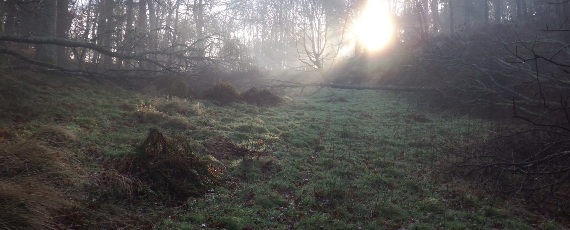
As I set off up the path the morning light took on a green tinge and I climbed the hill strewn with fine needles. The path zig-zagged up the hill and it was a good start to stretch my lungs and legs.


I got to the monument in full daylight and took some photos. I think I’d like to take my drone up here to give it a fly around. I got my breath and check my map before setting off. I had the walk planned on my GPS but still carried a 1:25000 and compass coupled with my route card.
The path headed NW before it intersected with a sign posted walk ‘The Maam Road’. I crossed it and set out across the moor following a quad/4×4 track up towars the first hill, unnamed but 304m. As I crested it I paused to I.D. the rest of the route and look for paths. There were none. The second hill, ‘Sgorr Racaineach’, I had mis-judged and a frontal ascent was not going to be possible. I was blowing hard as I passed it so instead of going back on myslef and climbing it I carried on to Crappich hill now firmly off any track.
I came across deer now as I approached Crappich hill and I could see some sort of tripod on the summit.  The air was still and it was silent. Absolutely silent. I carried on to Am Binnein stopping across the fence. As I climbed up the hill i felt the wind pick up as I climbed both Am Binnein and Sgairneach Mor. I saw more deer, bigger now not the small white bummed Sika deer but large red or cross breed anyway. It was heavy going through the heather now and I started to think about ticks.


Creag Liath sits at 499m and amongst the green and brown of the heather with some small but startingly red patches of lichen. I was over halfway through the walk and I could feel my energy flagging. I felt like packing it in and looked at my route ahead, some quite large hills with no paths. I had an option to take my escape route through the forest. I decided to stick with it and took a third of a Trek bar along with a large drink of water. As I surveyed the path ahead I could hear the croaking of frogs/toads. I looked across at some boggy ponds and could see some movement in the black water.
On the map there was a shelter. Looking at the shelter there was none. It had fallen down aided by the prevailing SW wind. I pondered and picked out my path ahead. It looked easier going following the fence and I set off.


Coming across more boggy ponds I got a flash of white as frogs/toads hurriedly submerged themselves as I approached. Little plumes of mud appeared in the black water as they settled in the ud. it was hard going up to Badincoul Castle and the wind picked up. As I approached a small cairn three black grouse took flight crying in alarm. Passing the cairn I carried on to the summit surrounded in black grouse droppings. My GPS had placed the summit 50ft to the east.
The next walk down the hill and then up Creag nan Eun looked to be a bit of a challenge but I slowly picked my way through the heather and rocks eventually getting to the summit. The views were stunning. The leaden sky had cleared and the wind dropped.


The views to the west showed more high moor with Loch Boltachan.
I turned to positively I.D. Wester Top and saw some deer to the NW of Wester Top. On closer inspection with binoculars it turned into a huge herd of deer. Probably 100 plus as they rounded a hill. I had never seen such a large number of deer together. I had seen them throughout the day and I guess I was shepherding them to the NW the whole morning.
Between Crag nan Eun and Wester Top it seemed to descend into a saddle of deep bog before rising again. Walking around the small Lochan to the west I set out on a bearing in clear bright weather. As I crossed the bog deep scarring was evident amongst the mud around Dubh Choire. Obviously used extensively by deer the area was just deer tracks with their hairs amongst the roots of the grass and heather. I found going over the softer parts fast stopped me from sinking in. As I started the final climb amongst the expose rock to Wester Top the wind really started to kick in blowing me along. My Alpkit Morphosis earned it’s place firmly amongst my kit. The summit was marked, accurately this time, with a small cairn about 30 – 40 cm high. I tucked myself in behind it and got a brew on the go.

I drank my energy drink in one in an effort to hydrate and because I didn’t want to have my kit all over the place in the hight winds. The wind was probably up around 25 – 35 kts. To vary my lunch menu when I’m out I found I had a sachet of cheese spread and a tube of ‘nutella’ type spread. Both were pleasant enough with biscuits brown. As I enjoyed my brew I was looking north to Invergeldie and Loch Lednock. I could see the extent of the track marked up the map up on to the plateau of Ben Chonzie and that might just be my next challenge.
As I finished lunch I contemplated my return. My timing was off by about 30 – 40 mins and that was after missing Sgor Racaineath. I was tired but had energy in reserve. Nonetheless I didn’t fancy going back the way I had come. It had been hard going at times irrespective of the climbs. As I looked around me on Wester Top I could see the clouds and sky darkening down to the SW. I elected to take an uncharted forest track which appeared to head in a general direction to intersect a marked forest track.
Shortly after setting off my decision was a wise one as the weather quickly started to close in. I followed the fence line down as it seemed to be the path of least resistance. My knees were in agaony in the descent and I was glad of my walking poles. As I came of the hill and into the treeline I judged the rain would be hitting me in 10 mins or so. I stopped and got dressed in my goretex, not a mnute too soon as I was soon engulfed in that rain that’s not in a hurry to come down but you just know is going to be on all day. I’m still getting used to wearing glasses all the time and have come to find them a real pain on a rainy day. I took them off and pocketed them they’d be useless now.
The descent was easy, quite steep in places but nothing difficult. The nearby trees had been stripped of the lower branches which in turn had been laid perpendicular to the path providing additional grip for the quads/4×4 heading up the hill. Lower down the branches had been broken and pulled down but remained attached to the tree. They created a pretty substantial ‘fence’ whether it was intended or not I’m unsure but I wondered if it was to funnel deer further up the hill.
The rain grew heavier as I reached the logging road. From there it was a straight slog back to Comrie. Head down the footing was easy but boring and it wasn’t until I was through Dunira estate that it became more interesting. There was a short walk along a path through some trees before I broke out on to Monument road leading down to Comrie and my car. The rain had eased as i walked down the road not recognising it from previous forays with some new houses having been built. As I approached the final bend before the car park I took the final half mouthful of water from the bladder. That meant I had 3.5l of water throughout the day and I probably could have benefitted from more. I arrived back at the car at 1601 meaning I had been out for 9 hours. It was about 12 miles and nearly 800m ascent. I was really pleased with that as I now reckon I can go for a few of the nearby munro’s having achieved this walk.
Getting back to the car and afterwards my hips were a bit sore despite the lack of weight in my bag. My knees were sore on Sunday but not half as bad as I thought they would be. I realised I was dehydrated though and continued to drink deeply Sat and Sun. I should have had a litre of water in the car with some of the SIS Nutritiion tablets in it. They’re tasty enough and just help you hydrate. Apart from the juice in the car I don’t think I’d change anything else barring the routecard and modifying my timing and slope allowance. Instead of 10mins rest in the hour I may increase it to 15mins. Certainly allowing for 3mph in that terrain was optimistic but I’ll know better next time.
