
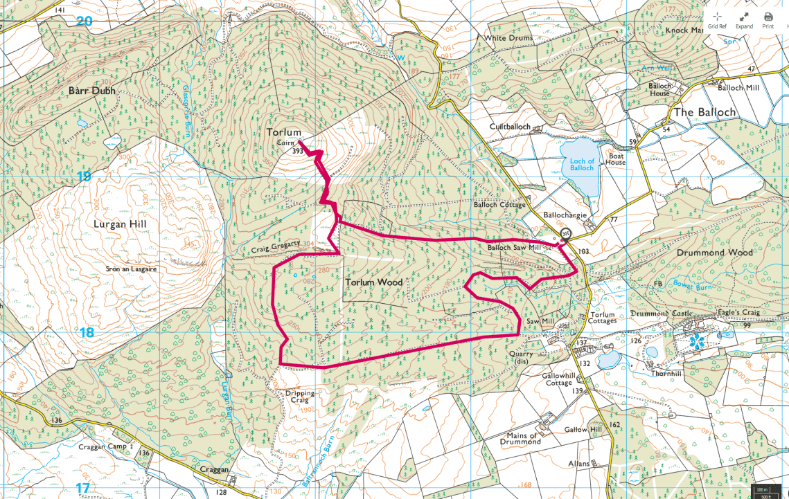
 So Turlem hill lies to the SW of Crieff sitting at 391m topped with an OSGB Trig point. I had tried this walk about 6 – 7 years ago but was exhausted mainly due to the footing and conditions and didn’t make it to the top. Since then I just never got round to climbing it.
Looking at the weather there was under 50% chance of rain. It didn’t rain but it drizzled or it was misty all day with a high percentage of water in the air. What the hell I thought lets get this done. It does bring an interesting viewpoint. Should you only go out to the outdoors in good weather. The benefit is of course you get the best of the days usually with great views. But of course going out in poor weather gives you the experience of operating in bad weather in case it happens when you’re out on one of your good days. I’m not necessarily a fan of the old military saying ‘it ain’t training if it ain’t raining’.
Kit selection today was simple, Goretex jacket, merino top, Haglofs Rugged Mountain trousers (my favourite walking trousers and even though they’re quite warm in the summer they have vents at the knee level). I stuck with my Scarpa SL boots as my Salewa boots have blown a lace loop and I’m struggling to get a response from Salewa. The Scarpa certainly don’t seem to cause as much pain after the walk as other shoes. My pack was the 14’r with a days walking load out (I’ll cover that another time) my Ribz and walking poles. I bought a pair of MOLLE pouches from a guy on BCUK that he’d had made for him. They are great little pouches, well made and a great size. I put one on the 14’r belt and put my camera in it. The other nicely fits my Keith titanium canteen with mug, lid and hanger. Nice. He bought them from this guy https://www.inguz-design.com/ I don’t have any other examples of their work but I’m very pleased with these.
So the last time I went out around Loch Leven I struggled with keeping my camera accessible and dry. I bought an Aquapac pouch to keep it dry and today was my first day out with it. With the camera and the waterproof pouch the side pouch was a perfect size to hold it securely and allow me easily access it. I just used the clip rather than the zips and it worked out well. The waterproof pouch was a bit of a pain to be honest. The lens extend out when switched on and if there was too much pressure on it the camera would reset. It wasn’t until I was looking at when I got home it might have been easier to put the camera in the pouch upside down then holding it that way. That would mean the seal was at the bottom and the pouch was upside down. The results were not the best I’m afraid and a number of photo’s the focus has been affected. I’ll play with it a little and see how it gets on.
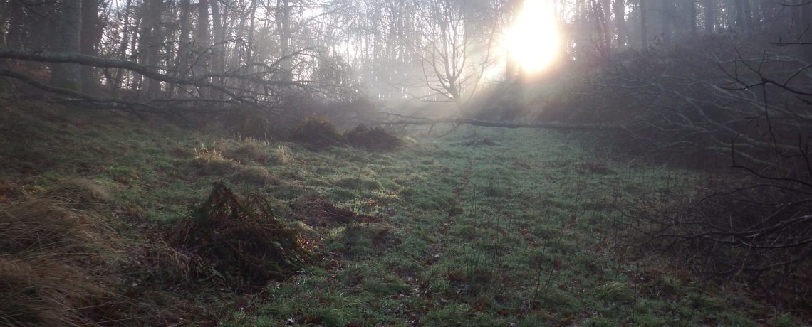
 So the walk, well I drove to near the trailhead. It’s through the yard of a local sawmill and plant maintainer certainly not an auspicous start. As you pass the yard the trail open up to the right and leads you through the trees. You immediately start to climb, it wasn’t vertical or anything just a long incline. It was a damp grey start and in amongst the trees, despite it being a well trodden route for vehicles, it was close and dark. I stopped not long after I started to take my goretex off. Whilst it was damp in the air and ‘mizzle’ (mixture of mist and drizzle) it was quite warm. The place was alive with the buzz of insects, genuinely surprising how loud they were. A wood pigeon was calling and all was well in the wood, well and still, very still. It was a mix of pine and broadleaves with shrubs at the road side covered in spider webs.
On the map there were a network of trails marked most of which were wide enough for logging machinery although most hadn’t had anything heavy through them in some time. The area is broken up by deer fences and gates and as I passed through the first of the gates there was evidence of clay pigeons. The area has, or had, a very active clay pigeon club and I remember seeing a lot of the detritus the last time I was there.  It became more overgrown and a steeper climb through the gate which in short lead to a second gate. Through this gate the hill opened out to ferns and what should have been a view of the hill top but it was all obscured by mist. It was almost instantly cooler on the open hillside and fresher. The trees changed to mainly broadleafs at this point and it became less of a plantation. At this point the path diverged to three options, now you’re not miles away from a road or on a high dangerous hillside but a map or compass gave you the right direction and path. I’m quite happy navigating with map compass or GPS but it’s not something I have my head into all the time.
The path had now even less signs of use and the centre of the path instead of grass was now heather. A jay was squawking through the trees as I disturbed the area walking through it.  As I continued to climb more of the bed rock became visible on the path making it slippy in places. The mizzle turned to full on drizzle as I cleared the trees but the top of the hill remained obscured. I didn’t bother putting my goretex on as it was too hot with the climb and conditions. On the OS Map the path changed from double hashed line to a single hash line. and wound it’s way up the hill. I missed the path and walked past it as it was through some thick ferns. I saw it but thought it was a little too small and a deer or sheep track. The path was through some thick ferns which did concern me, mainly due to the risk of ticks. What I should have done at this stage was to put on my goretex. With the amount of water on the ferns I was pretty wet going up the hill.

This was near the top of the hill and it was getting steeper and the path narrower. As I got through the thick ferns the path cleared a little and became a bit more defined. Looking at the shrubs I noticed that they were blueberry bushes with lots of fruit on them. They must have been just past their best, half of those I picked burst in my fingers but I got a handful and they were juicy and a little sharp. A welcome handful though even though my fingers were stained for the rest of the day.
It was only in the last 50m of the climb that I was actually able to see the trig point fuzzy in the mist. I made my way up to the small hillock peaked by the trig point. It was ferns and blueberry

bushes all around but the small hillock was just grass. I decided to stop and have a brew here with a Trek protein bar. It was back to my little evernew and meths burner although I put it in the lee of the trig point for shelter from the wind. I put on my new Alpkit Mephisto windproof jacket to take the edge of wind chill and it did as it was advertised. Cut the wind off right away and gave a bit of insulation but not enough to make me overheat. I understand the OS aren’t maintaining the trig points anymore and this one had been vandalised, the centre had been removed and the actual data marker had been vandalised by the look of it by a chisel. As I sat with my brew I decided not to dwell, it was grey, wet and there wasn’t anything to see beyond 50m. I took a few photos and off I went.


Remember the thick ferns and the map and compass I mentioned earlier here’s were they would have been of use. I missed the path again but knew I had to go downhill. I noticed a patch of undergrowth that I knew I hadn’t seen on the way up. Looking quickly at the GPS I could see I was way off the path but just above the trail end of the path I’d been following.


I took a quick bearing just to make sure I was heading in the right direction this time. As I got through the ferns onto the path it was plain sailing and I headed back through Turlum wood. I could have headed down directly the way I came but I wanted to extend the walk and followed a meandering route through the wood.
When in the plantation proper amongst the trees it was silent again and just so peaceful and calming. The buzz of insects rose again and it was quite dry amongst the trees. As the path descended steeply the ridgeline was exposed to the right.  A buzzard was hunting in the area and the cries were eerie with the mist, the silence and the darkness. As it became more overgrown the smell of pine resin was powerful and far better than the pine smelling air freshners. Amongst the trees splashes of light showed the undergrowth up as nearly flourescent green. My camera didn’t pick it up when I tried to take photo’s and I hadn’t brought a tripod. I wished I knew about mushroom identification because the number and variation of mushrooms was incredible.


If I did know and they were safe I’d have been able to have a feast of wild mushrooms. Looking to the south through the trees there were glimpses of Meall a’Choire Odhair hill and Dalchirla farm of Black face sheep fame. My chosen path was to the east and was flanked on the right by a high deer fence.
Further on the area had been harvested and churned up by the machinery. It was at this point again I had to get my map out and check the area. My chosen route should have

been evident but with the harvesting it was all just churned up. I took a bearing from my GPS to where I should have been heading and set off. Eventually something like a path became evident before I decided to follow the route taken by the plant. The dry weather of the summer was evident, even amongst the rain that we’d had what had been deep thick mud was now just crack solid ground. I was surprised because we’d had
quite a few days of rain since the blistering July. The route of the plant and the path converged and I strode out downhill. Right at the end of the path I came upon the only other person I saw, a gent out walking a couple of wet and likely to become muddy labs. I got down on to the road about 50yds from the car.
It was a really great day, physically exerting, I hit a peak I’d failed before and I got loads of fresh air. I definitely think that time spent amongst trees is good time. The stillness and quiet, even of a plantation does take you away from the world and your troubles. I should really spend more time amongst them.
