
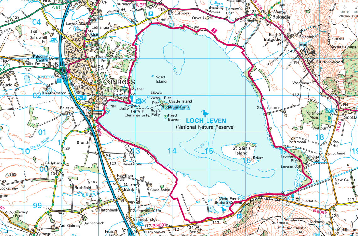
So the plan, a multi-faceted one. I’ve been knocking off a 5 – 6 mile hike with a bit of a climb in it with ease. Great, now I want to extend the range and to do so without killing myself. How to manage it? Well don’t climb. To that end one of the walks I’ve always fancied was a circumnavigation (an elaborate description considering it has a good path around it) of Loch Leven at Kinross following the Loch Leven Heritage Trail. Great, love the plan, what else can I add to it; Well theres lots of birds around the area so lets bring your DSLR with your big lens. I know even better, bring your drone and do a whole video shoot. Wow, who’d ‘ave thunk of such a great plan!
Best laid plans and all that, forecast was wet. The forecast was in fact very wet and all day.  Hmm do I want to lug my camera in a dry bag then decide that it’s raining too heavily and I don’t want to take my camera out? Ditch the camera. Drone? No, electronics and moisture are usually best kept apart, so no drone. Okay no bother a simple walk it is. The camera may not have been such a problem as I came across a number of hides if I’d been so inclined. In reality the drone probably wouldn’t have been a good idea with the amount of geese and swans in the area and I’m pretty certain the RSPB to the south of the Loch would not have been keen to see it airborne.
I drove to Kinross heading for the pier with it’s car park. I was a little later than I wanted to be but with the rain I wasn’t expecting it to be busy. The car park was right at the trailhead and it was a lovely little harbour. A shop and restaurant was right next to it but all were closed at 0900 on a Sun.
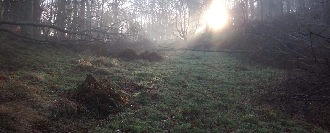
The pervading colour was grey, grey and wet. That would be it all day. The rain was on all day in varying strengths but it was ever present. This affected my choice of clothing; merino top, Scarpa SL’s, goretex top and bottom and for trousers I wore a set of Ron Hill Trackster Trek. Such a 1990’s hill walker look. A combination of Max Wall and 1990’s walker. It was never a flattering look but comfortable. I didn’t know whether the Ron Hills would fit but pleasingly they did and without being uncomfortable. The reason I wore them was that I knew I’d be in Goretex trousers all day and I know they’re great for wicking moisture away from you. Craghoppers technical and my favourite Haglofs Mountain Trek Pants I don’t know how they’ll perform under goretex and I didn’t want to find they were pants. So the Tracksters it was.
As mentioned earlier the carpark is right at the start of the trail and theres a lovely little harbour there.  Views out to the south and east were just grey, the islands were a darker grey land mass but the hills were visible. I set off along a raised wooden walkway taking you over a boggy piece of land before getting on to dry land and onto the path proper. The path quickly opened up to a play park, car park and toilet block. There were a few campervans parked up overnight. The wall for Kinross House was to the rear and towards the end of the wall there was a cemetary.
  It’s a commonwealth war grave but I didn’t hang around to determine the details. What did sadden me was a small plot of graves and a stone cross seeming outside of the main cemetary. It was obvious a number of plaques had been removed from the cross. My guess is that they were brass or bronze and had been removed to melt down for money. A truly heinous crime. At this stage the loch is pretty open with paths through the undergrowth to the waters edge. The loch is obviously well used and for safety there are a number of containers with throw bags/ropes in them. As I reached the corner of the cemetary there was a map which encouraged you to use a canoe or boat on the loch but limited you to the area in the centre of the loch lest you disturb the nesting birds. To be honest it didn’t seem worthwhile.
Knowing that I would be writing the walk up it suddenly came to me that I should be making notes in some shape or form to remind me of the walk, the temp, sights, animals, flowers etc.
 This led me to think of a small rite-in-the-rain notebook I had and that I should be using it for notes. I looked it out when I got home and with no plans for the bank holiday I made a holder for it. It’s a little bit rough but it’ll do the job paired with a RITR pen. I covered the front and back in velcro so I can put a patch or two on it.
The path then carried on around the loch through the trees. Between the path and the loch it was overgrown with brambles, ferns and long grass. The opposite side is pasture and open fields. As you approach the golf course on the left the path becomes flanked with trees mixed broadleaf and pine. The path is about 20 – 30m from the loch but it’s obscured and the access is over a fence, obviously they’re keen to keep you off the waters edge. I guess it’s to restrict access so the birds aren’t disturbed.
I came across the first of the free access wildlife hides. It’s simple overlap wooden planks construction with windows inside that you can lift and secure for you to look out. There are bench seats and it was quite cozy on a grey rainy day. I have to say I was impressed with what it was. I came across a second one later in the walk which was equally well appointed but with a long wooden walkway to reach it. By the time you got to the door you made so much noise on the walkway you’d likely scare every scrap of wildlife away for the rest of the day.


It was still raining and very grey, I was fully enclosed in goretex bar my head where I wore my Tilley hat. I only like to have a hood up for the worst of the rain. The thing about goretex is that you sweat, thus the need for clothes that’ll help wick the moisture from your skin, so you need to drink. Now I planned to bring only a litre of water and replenish from the loch. I decided not to and was rather glad that I didn’t. There were warnings at the start of the walk that the hot weather in Jul had promoted algae growth so the water could cause stomach upsets.  I had obviously planned to clean the water but the access would have been limited to a few spots by the loch and a few streams.
The other issue with the rain was that all gear that could be damaged by excessive moisture had to be put into a dry bag. This included my camera, I had taken my Sony RX100MkV, I put it in a normal dry bag which was only half full and just folded it over inside my Ribz. I need to get a waterproof camera case that will let me operate my camera still in the bag but protect my camera. Doing some research asking on a camera group on FB they recommended the Aquapac 418 bag. I’ve gone back to Aquapac to see if they have any other recommendations. Update – Aquapac came back to me and recommended the 448 bag. This appears bigger and is on sale at the minute for £19 so that may well be the one.
The path was very well kept and I’m guessing would have been accessible to most although the access points on to the path aren’t too numerous so you may find that you have to walk a fair distance between them. As you continue along the path farmland opens up to the left with some hedgelaying, I’ve only seen it on tv, and what looked like fence of willow hurdles. Geeky I know but it’s not something you see everyday. As I approached Burleigh sands there were a few tents by the loch shore. I don’t know how comfortable I’d have been camping by the shore right next to a car park. I don’t know how their camping was working out. It looked like one tent was completely blown over and the fire they’d lit was at risk of blowing sparks onto the other tent. Hope they had a great time. This marked one of the few points of direct access to the loch.
As the path continued there was a welcome sign to Loch Levens larder. A great farm shop and cafe. This is about 3.5 miles into the walk and would be a good place to stop, refresh, then walk back or with two vehicles drop one at the farm and one at the pier. There was a lot going on at the loch when I walked it, at Loch Levens Larder there was a walk/run in aid of Parkinsons. Later in the day at the car park I came to earlier by the cemetery there was a boat race on recreating the escape of Mary Queen of Scots from the island. It’s a busy popular place.
The path continued through some woods a really enjoyable part of the walk again a mix of pine and broadleaf trees. It was roundabout now (remember the benefits of the notebook I mentioned earlier) that I started to see more people on the path. I saw runners, cyclists, dog walkers and other walkers like myself. I wouldn’t say it was busy but its used. The path was marked by stone posts with directions and distances on it. A minor thing but it annoyed me that it was marked in kilometres. I understand them and can convert them to miles but it irked me.
 Gaps in the treeline to the east gave glimpses of White Craigs and Munduff hill. This and other hills certainly present other opportunities to expand my horizons and walk in unfamiliar areas getting outdoors more often and doing something to combat my weight and overall health. Certainly views of the loch were non existent or very small.


There were a number of chunky wooden benches along the path most with a nice little round plaque on the seat back and a poignant or relevant ditty carved into the back of the bench. They weren’t always easily seen with the aging of the wood and lichen growth but it was a nice touch and some had great views across the farmland or on the open loch.

As the path reached the south eastern corner of the loch it crossed the river leven who’s path was all man made and used in mills and other works in the area. The small bridge crossing it had a number of carved sentences almost lines of poetry. I understand that a number of councils put lines of poetry up in similar settings to demonstrate their contribution to poetry and the arts. I recently heard a rather disparaging debate about it on R4 (I was cooking and my hands were covered in stuff so I couldn’t turn it off/over, I’m not that highbrow). Crossing this bridge changed things not only the immediate surroundings but crossing that bridge did in many respects end the interesting part of the walk for me.
Crossing the bridge there was a warning of traffic and  to give way for vehicles going to the sluice house. This house on the south east corner, now a private home, is where the volume of flow of the river would have been controlled from. The sluices are still in place and I guess working and controlled but the house is private.
  I would think the people who live there have been plauged in the past with people walking into or around their garden so there are a number of warning signs up. The route jinks to the left here and leads down an overgrown almost tunnel like path to the loch beyond. This was one of the best and most open views of the loch I’d seen since the early part of the walk. It was still raining but I thought it an opportune moment to cook up a brew, have some lunch and take a break using one of the aforementioned benches.


I could easily have taken a flask but getting a brew on is always that little bit more fun. I used my Alpkit Titanium mug and my Evernew stove and meths burner. After years of trying various concoctions to get a decent cup of tea outdoors I have eventually settled on Carnation condensed milk. It obviously makes the brew sugary but it’s the only decent addition I found bar bringing fresh milk. The condensed milk and peanut butter along with biscuits brown do not make for a diet friendly meal but I was exercising and it’s convenient. It was damp but not completely pissing it down. The phot of my seat cushion there had been sat out for a minute or two and you can see it’s getting wet already. I was sat there for about 30 – 45 mins just enjoying being outside. Sometimes just stopping and taking the air can be cathartic in itself.
Setting off from here was less of a pleasure as the road, B9097 was close by to the left. Not the busiest of roads but constant noise.  This was now the coming onto the RSPB controlled land. They have a visitors centre here, I chose not to go in for no other reason than I couldn’t be bothered. I had planned to take a walk along a different path f evident using OS Maps. As it turned out this was the ‘Wetland Trail’. There was a diversion at this point with the main path a building site so the only viable route was the Wetland trail. A sign at the entrance stated the path was free but the bird hides were only allowed for members or ticket holders with tickets on sale at the nearby visitor centre. I’m wondering of the intention is to build a subway to the Wetland Trail with the Loch
  Leven Heritage Trail going over the top and the access to the wetland trail’controlled from the visitors centre. It was a pleasant enough walk along the path and the various signs discussed the bird and insect life prominent in the area which had been developed close to what it would have been like in the past albeit now on a far smaller scale.
  Geese are prevalent in the area and there were a quite a few around on the day.
  Commendable work and the location of Europes first Bee sanctuary. Rejoining the main path again puts you right beside the road. What I did observe though is that the brambles this year could be a bumper harvest certainly the bushes were loaded with immature fruit. The odd berry that looked decent enough to taste were located low down. My dad was never one to mince words and I hear his voice in my head warning me when I see a similar sight ‘Thems the ones the dogs piss on’, wise words Dad.
The attraction of the path really goes down hill in regard to interest and attraction. To the left is the road and Castle Craig beyond it, to the right a mix of wetland and pasture.
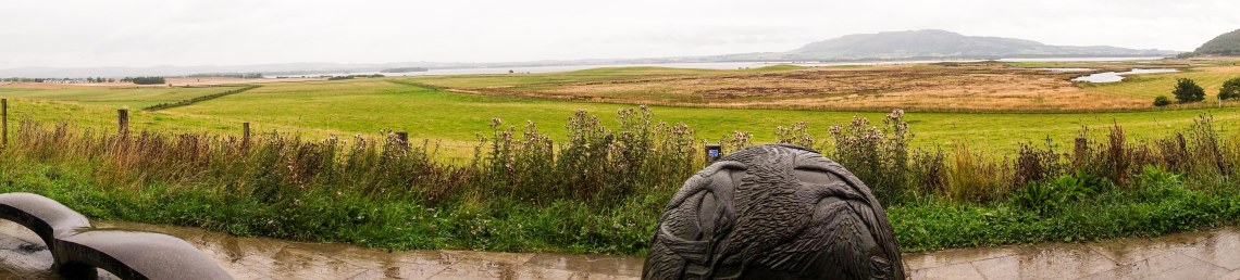
  This kept you well away from the lochside and I was surprised how this was maintained most of the way around the loch. In the distance is a small hill 125m with a great viewpoint and shelter built by the RSPB. The views over the wetland and loch are truly great and on any day other than the one I chose they would have been quite spectacular. There was a beautifully carved shpere of granite with birds in relief representing the most common birds seen in the area.
The path truly became mundane matching the mood of the dreich day, my tiredness were no doubt all playing a part at the last third was a  trudge indeed. My only relief was coming upon two deer at a stream about 10ft away but as I struggled to subtley get my camera out they were off. Another deer saw me coming from some way off and ran to the far side of the field. As he stood by a tall fence, I think designed to keep him out, he assessed my approach. Deciding that he really didn’t like me he jumped over the fence which looked to be at least 6ft tall from a standing start, impressive beast. The path was flanked by farmland from here on out and the loch not visible for most of it. Even the final stretch leading up to Kinross the loch was behind a bank, obscured by fencing or trees. The final stretch was along the old railway closed as part of beeching closures no doubt. This is marked by a rather nice graphic on some upright logs, I’m guessing representing the railway sleepers.
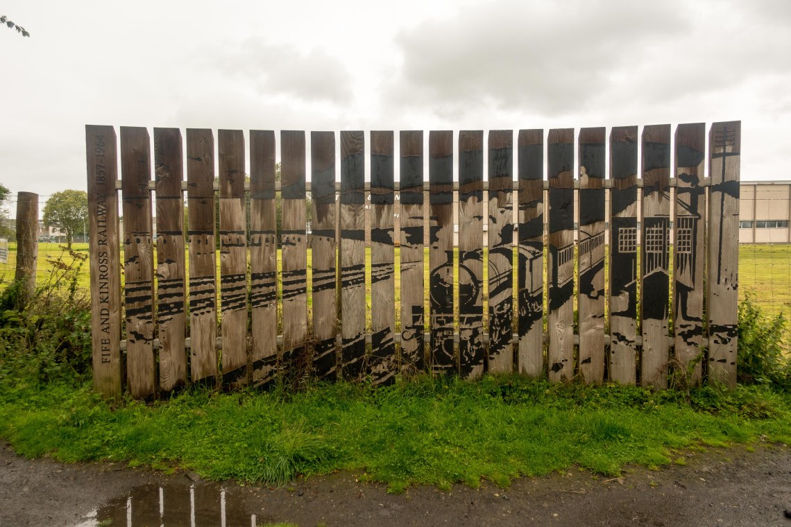
I would hasten to add at this point that I am not and never have been a railway aficionado.
The walk came to an end as I skirted the fence of the Todd and Duncan Cashmere spinners and into the carpark. It took me five hours in total that included stops, visiting wildlife hides and lunch probably about four hours on the move for 13 and a bit miles. My GPS, Garmin 64st a relatively new piece of kit, was not displaying the data I wanted and did not zero at the start as desired. I was not that impressed by the display so I’ll revert back to my Satmap for the future.
The walk itself was pleasant enough but would I rush back to do it all again…no. I’d maybe come back and do elements of it, visit a hide or the RSPB visitor centre but the walk didn’t have enough for me to make it a regular. I didn’t get all the data I want, down to my own fault, regarding moving time, distance etc so if I wanted to use it as a marker to judge my speed and how I felt I couldn’t with any degree of accuracy. I did achieve my ‘calories used’ (850kcal) twice round on my Apple Watch and did my exercise (30mins) nearly 6 times. So all kudos to me for doing it but I need to improve speed a little especially across easy ground, and this was easy ground, and generally my endurance. My next walk I think I’ll be looking to do a longer walk with hills, I have a Munro above the town with a really steep climb but probably achieveable if I am gentle, there is another walk along a hill range along the A82 past Comrie. They’re not particularly big but there’s enough up and down over the summits to make it worth my while.
